147: From Freeway to Boulevard - Pt 1: Design
147: From Freeway to Boulevard - Pt 1: Design
|
Administrator
|
|
This post was updated on .
I think that whenever the I-85 connector is FINALLY completed, this needs to be seriously explored because there's no reason to have an aging freeway running through a fast-growing urban area when there's a brand new interstate a mile away. I am pretty sure that a 147 rebuild is on the horizon given its age, and Durham shouldn't settle for a new freeway like Winston-Salem did.
This would be my preferred alternative. Coming out of the interchange with the I-85 connector, 147 would instead follow the tracks more closely and merge onto Pettigrew St. It would follow Pettigrew up to Fayetteville St, where it would then transition onto Jackie Robinson Dr. At the ATC, 147 would transition back onto the current ROW. At the Chapel Hill St intersection, it would shift over just slightly onto William Vickers Ave before transitioning back onto the existing ROW. As 147 approaches the Duke East Campus, it would transition onto Erwin Rd briefly before reverting back to the current ROW once past the Anderson St intersection. From there, 147 would follow the existing ROW up to US 15/501 at which point it would transition back into a freeway before merging with I-85. 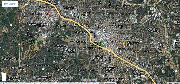 I'm not sure how realistically feasible any of this is, but I think that the section from the I-85 Connector to ATC wouldn't be that difficult, and would allow for construction of the urban boulevard to commence without disrupting very much traffic. Also, rerouting 147 onto Pettigrew/Jackie Robinson would allow for the complete removal of the existing route which would result in normal-sized blocks, instead of tons of roads all parallel to each other within the same block. Edit - been playing around with this for wayyyyy too long. I decided that extending Morehead St from ATC to Alston Ave by connecting various exit ramps and side streets, then having Morehead follow the existing 147 ROW to the I-85 Connector would be a great way to have a second urban road parallel to Pettigrew. This would allow for the removal of the Freeway, but would avoid creating absolutely massive blocks south of Pettigrew/Jackie Robinson. Both Morehead and Pettigrew would run parallel from ATC to Briggs Ave, at which point both would revert to one-way streets and morph into a freeway. I think that Morehead could be the higher volume route, while Pettigrew/Jackie Robinson could be a lower volume street that is designed primarily for bicyclists and pedestrians. At the ATC, where 147 would rejoin the existing route and carry higher traffic volumes, while bicyclists and pedestrians would be routed along a different parallel road (maybe Main St). 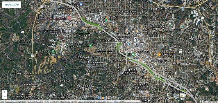 Here is the link to my map on Google Maps if you want to look at it more closely. (You'll probably see other infrastructure ideas around the Triangle as well that I've toyed with). Not perfect but I think it addresses most of the issues that have been raised about building an urban boulevard. |
Re: 147: From Freeway to Boulevard - Pt 1: Design
|
Administrator
|
This is very cool - thanks for sharing.
It's great that you solved one problem that I brought up (parallel streets close together) and another problem that I didn't (construction disruption). The next post in the series goes into some of the math, but I limited the length of the boulevard because I thought that the return wouldn't be able justify the construction costs further out from the core. That said, if there would be a need to rebuild the freeway anyway, perhaps some of those funds could be utilized for a longer boulevard, which could create nice, first ring, dense residential neighborhoods with their own, smaller commercial footprints. |
|
Yeah, I wasn't sure where it should start or end, but ideally I think the less freeway between the I-85 Connector and I-85, the better. I remember about a mile long segment of Bus 40 (Peters Creek Pkwy to the Innovation District) in Winston-Salem was rebuilt a few years ago for just over $100M, which included the replacement of 8 bridges and the construction of 2 pedestrian bridges. I think $100M would go farther here in Durham because freeways are more expensive to rebuild than normal roads.
|
|
Some numbers for my scenario in the above posts:
The continuous section between the I-85 Connector and US 15/501 (running along Pettigrew, Jackie Robinson, William Vickers, and Erwin) is 5.66 miles. The Morehead Ave section from ATC to Briggs 2.31 miles. There are a bunch of side streets and other miscellaneous street reconnections that are probably around 1.5 miles in total. All of the green sections in my map add up to just over 100 acres. Granted, this figure is based off of tons of rough estimates of where ROW/existing property boundaries are, but should be fairly close to an official survey. Tough to put a number on how much those 100 acres are worth because property values vary massively depending on where you are along 147. The ATC area looks like about $1.5M-$2M per acre (before improvements), but drop off pretty rapidly the farther away you go. However, if development starts to crop up along this corridor, you'll really start to see those values skyrocket - Van Alen has a taxable value of $77M, and about $70M of that is the building. 555 Mangum has a taxable value of just over $38M, and $32M of that is the building. Combined, that's over $100M worth of improvements in just one block. Definitely playing the long game with these numbers, but I think the increase in tax values would probably eventually cover the cost of the conversion. |
Re: 147: From Freeway to Boulevard - Pt 1: Design
|
The traffic volume on NC 147 is significant. Average daily traffic counts by segment:
23,000, I-85-15-501 45,000, 15-501-Hillandale 62,000, Hillandale-Swift 68,000, Swift-Chapel Hill 67,500, Chapel Hill-Duke 67,500, Duke-Fayetteville 89,000, Fayetteville-Alston 79,500, Alston-Briggs 75,500, Briggs-East End Connector (I-885) I-85 across Durham carries 100,000-110,000 per day now between 15-501 and US 70. https://ncdot.maps.arcgis.com/apps/webappviewer/index.html?id=5f6fe58c1d90482ab9107ccc03026280 The opening of I-885 will shift some traffic away from the freeway to I-85, but a significant volume of locally-generated traffic will remain. |
Re: 147: From Freeway to Boulevard - Pt 1: Design
|
Administrator
|
Fair - and if the remaining trips are locally generated, then I am thinking that there should be a more local solution.
The traffic counts on 147 are a good example of induced demand. If 147 didn't exist, the downtown street grid (as imperfect as it is in Durham) would more than be able to absorb the trips due to the fact that a grid of many interconnected streets has a surprising amount of capacity. A boulevard would be a much better solution for people living in the area. The only people that would be negatively impacted would be the "through traffic", which would now have the connector to 85 to switch to. Traffic counts would be absorbed by: 1. I-85 connector 2. Other routes in/around downtown 3. The boulevard itself. With 4 lanes, albeit slowed down, it will still have decent capacity as a major roadway. Those numbers are fascinating though regarding the lower volumes as you get towards downtown and lower still as you get to I-85. |
|
In reply to this post by CarolinaFan
Seems to me that there isn't a lot of through traffic going all the way from I-85 to the Connector, and the bulk of traffic is either heading to RTP or just trying to go a few streets down 147. I think that by having multiple streets running parallel to each other, the congestion that does exist will be mitigated, and at least theoretically those short trips could be walked or biked more feasibly as long as the streets are designed correctly. But I'm just an armchair traffic engineer.
|
|
This post was updated on .
In reply to this post by Dave @ Building Bull City
Hey everyone. I'm new to the Triangle from Atlanta and just came across this. I'm a Transportation Engineer. with the opening of I-885 this is actually a GREAT idea and could transform Downtown Durham. This should really be explored.
Mind if I draw it out conceptually in MicroStation? I have a couple of ideas start / end limits wise etc. |
Re: 147: From Freeway to Boulevard - Pt 1: Design
|
No one minds if you draw it out. I'd love to see it. Anything we can do to make this happen.
|
|
Have been so busy but I finally got some time today to start laying it out in CAD.
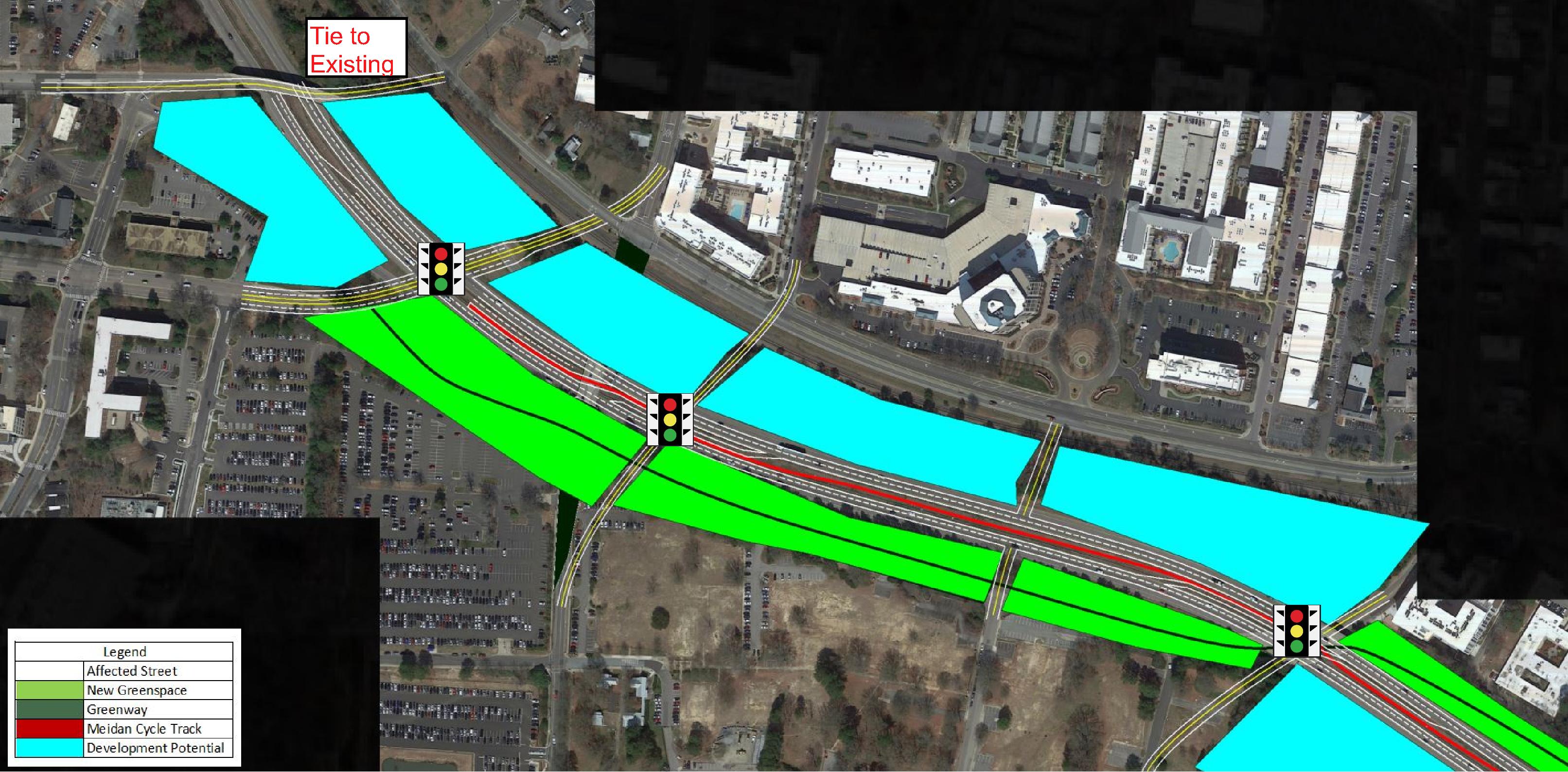
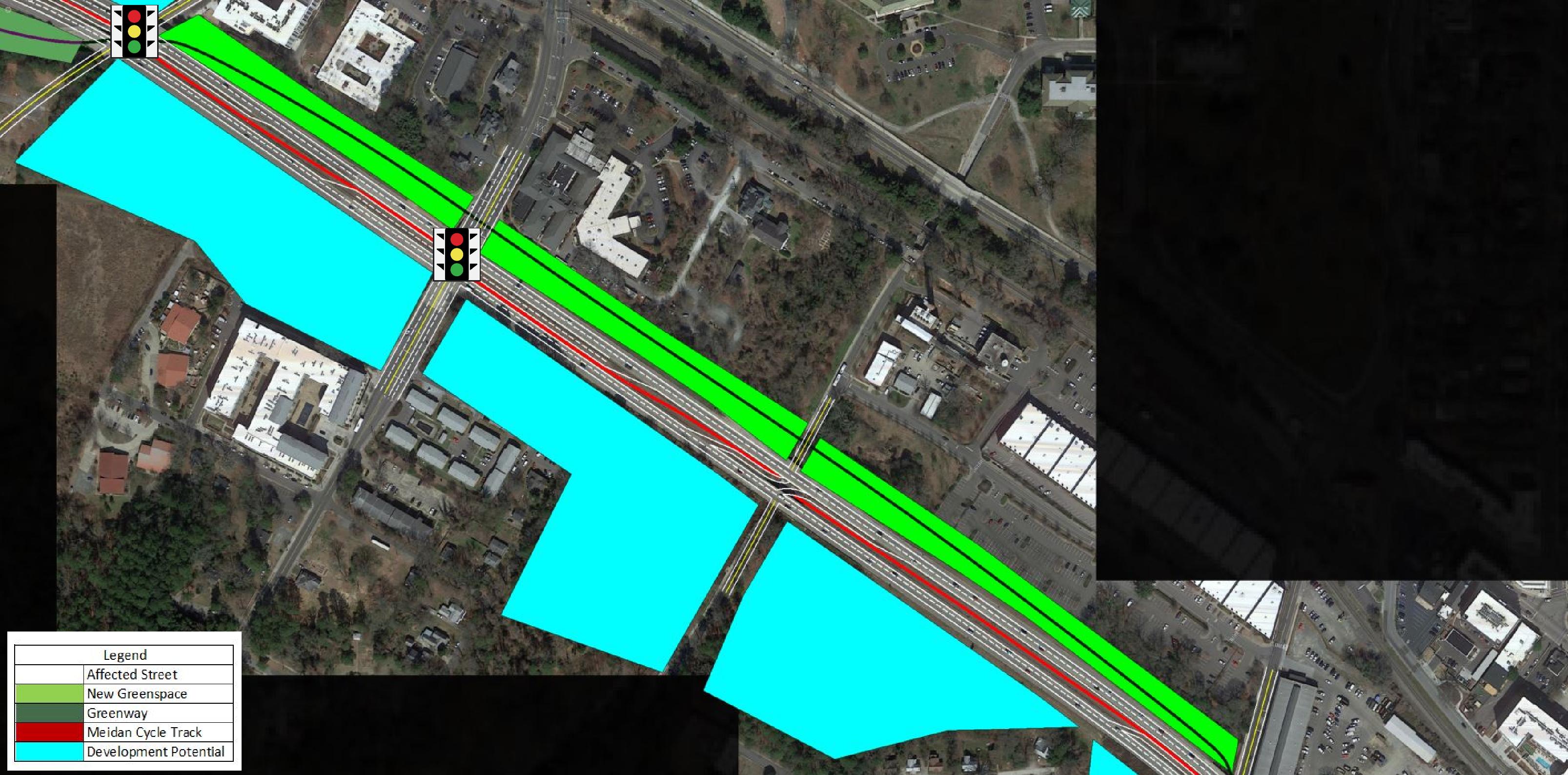
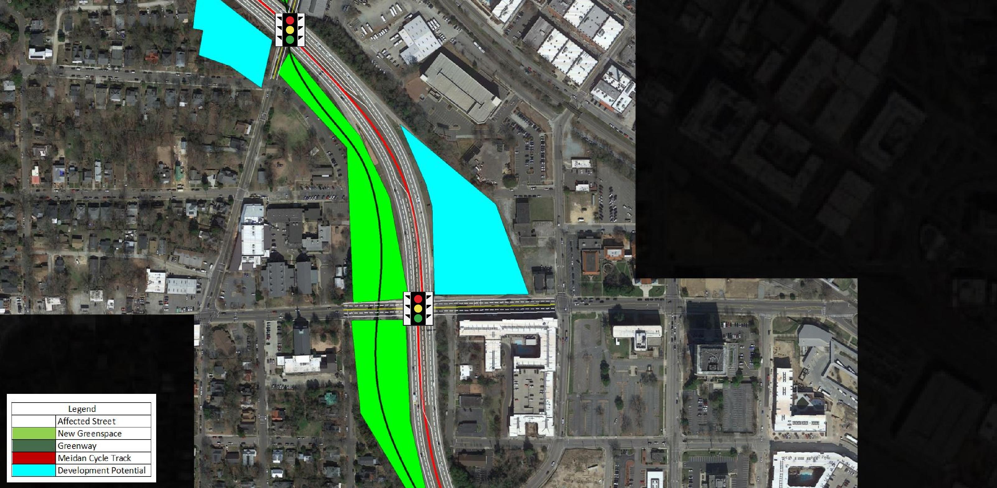
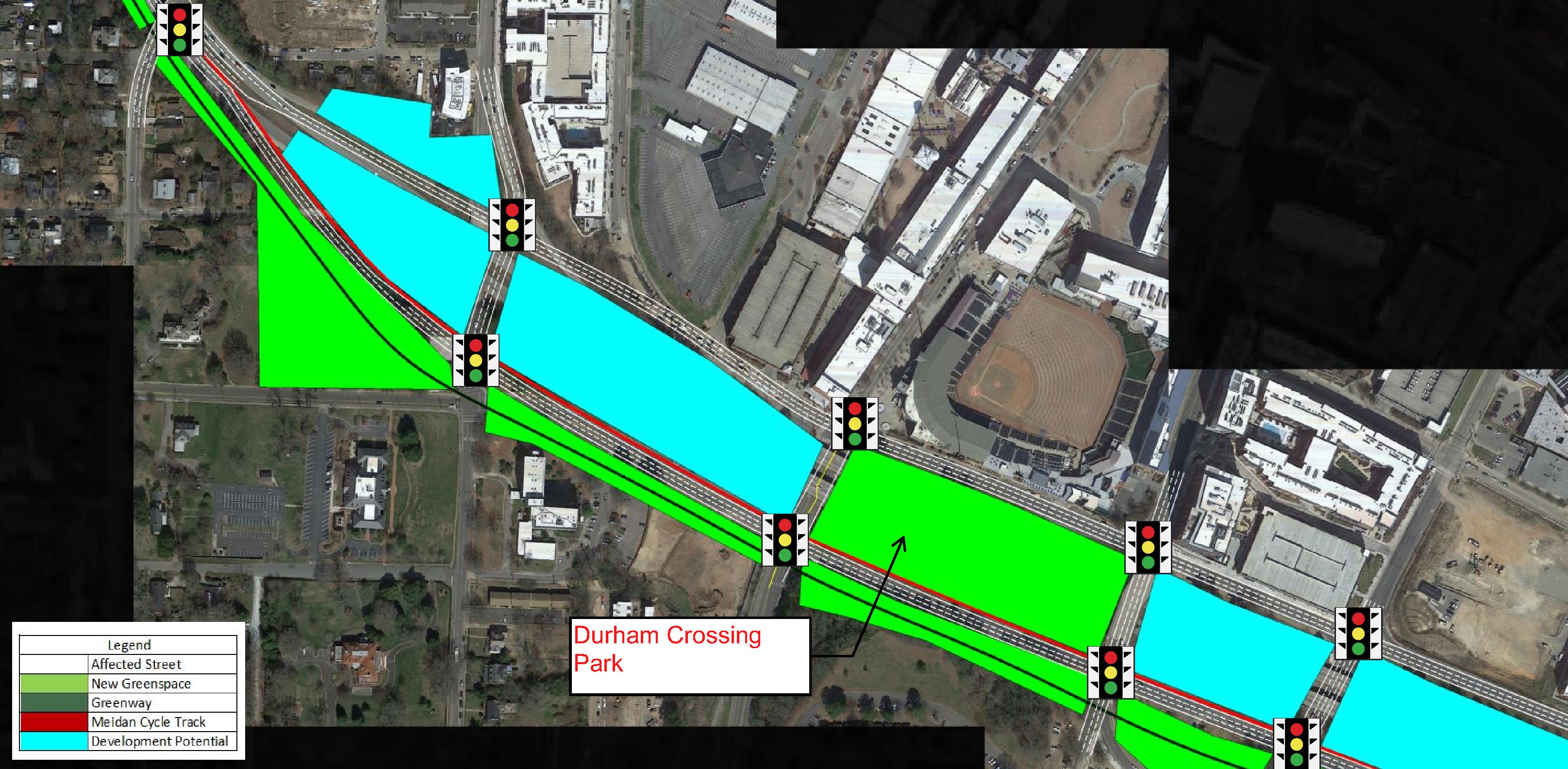
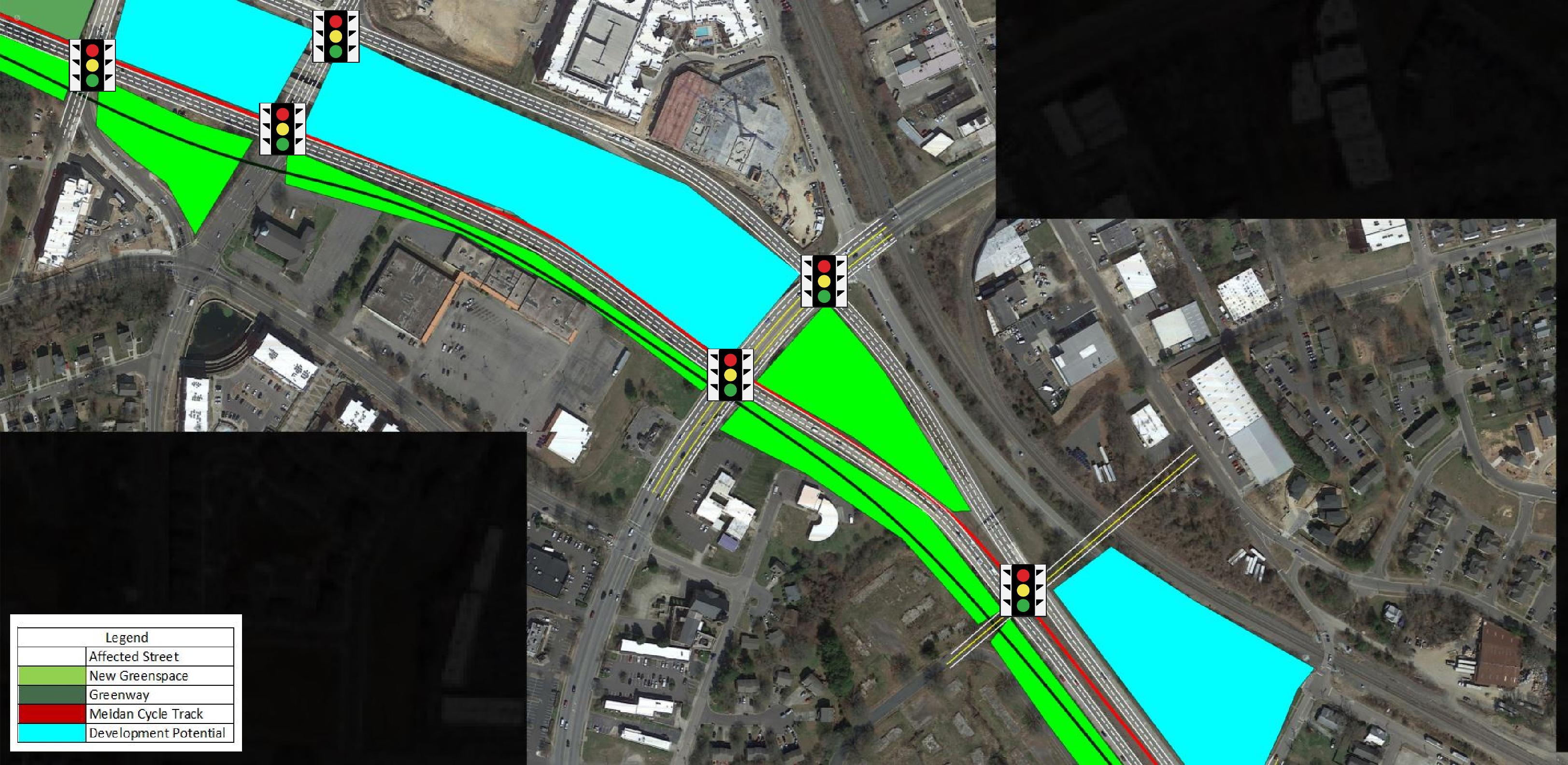
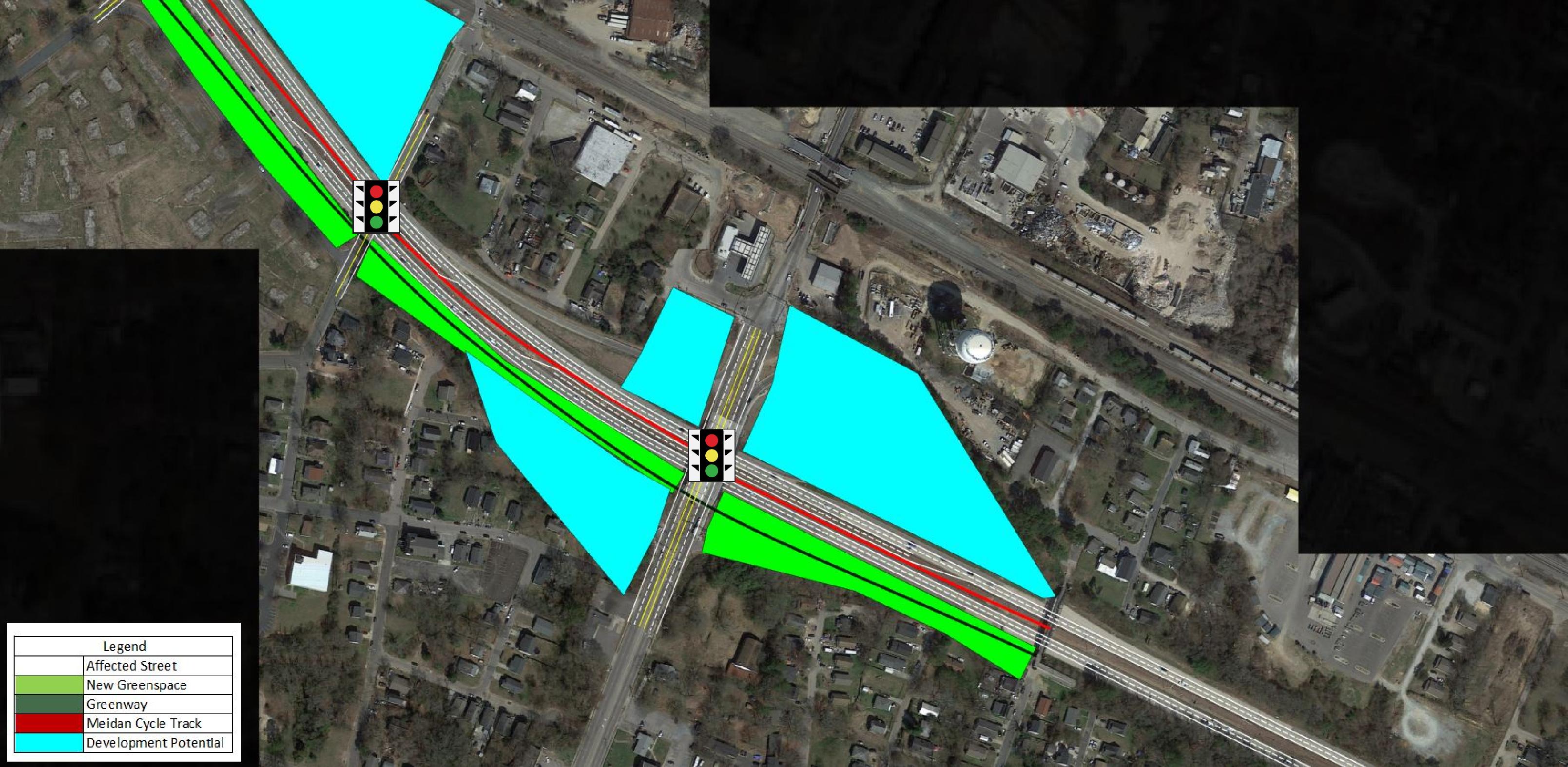
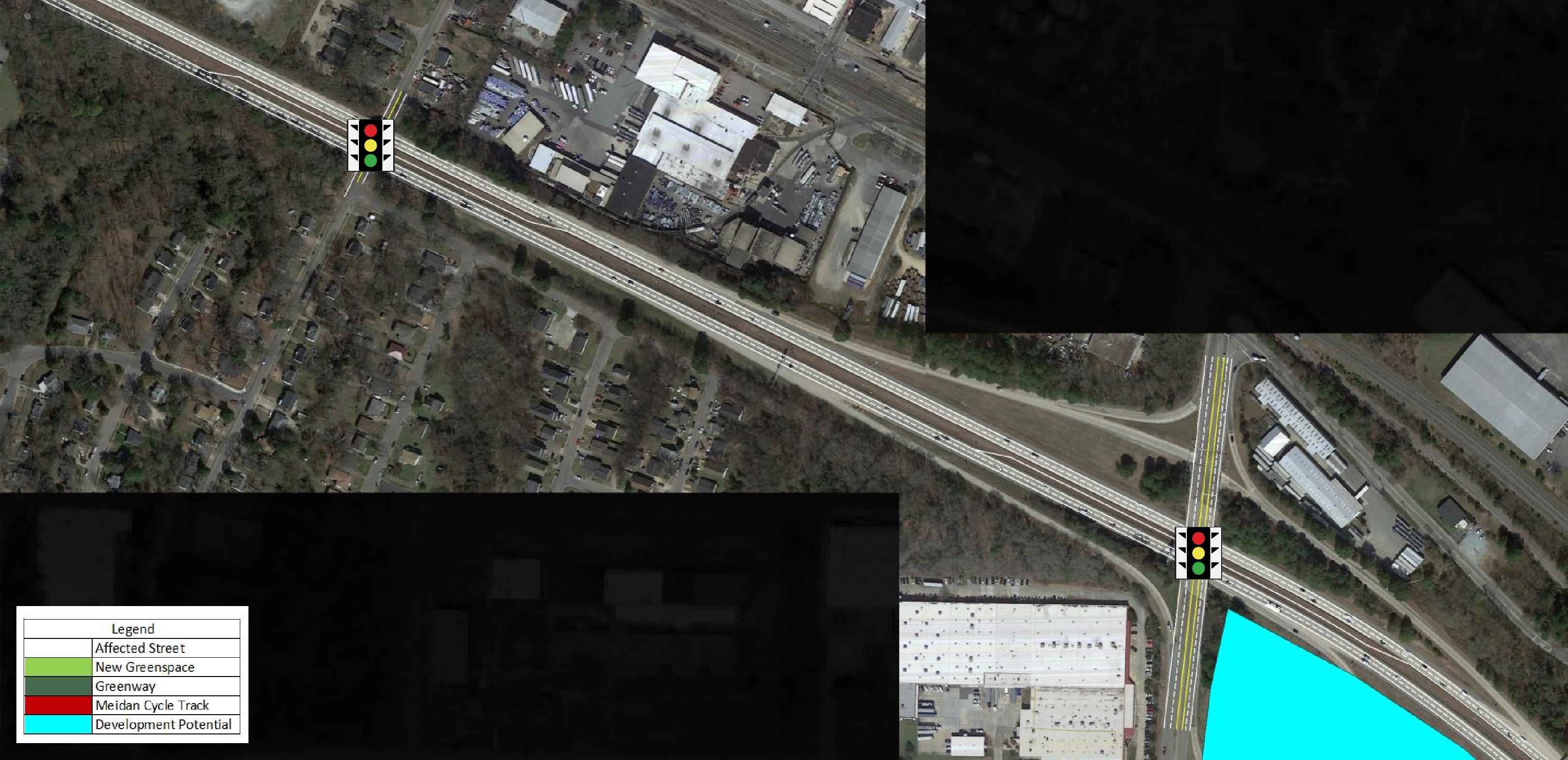
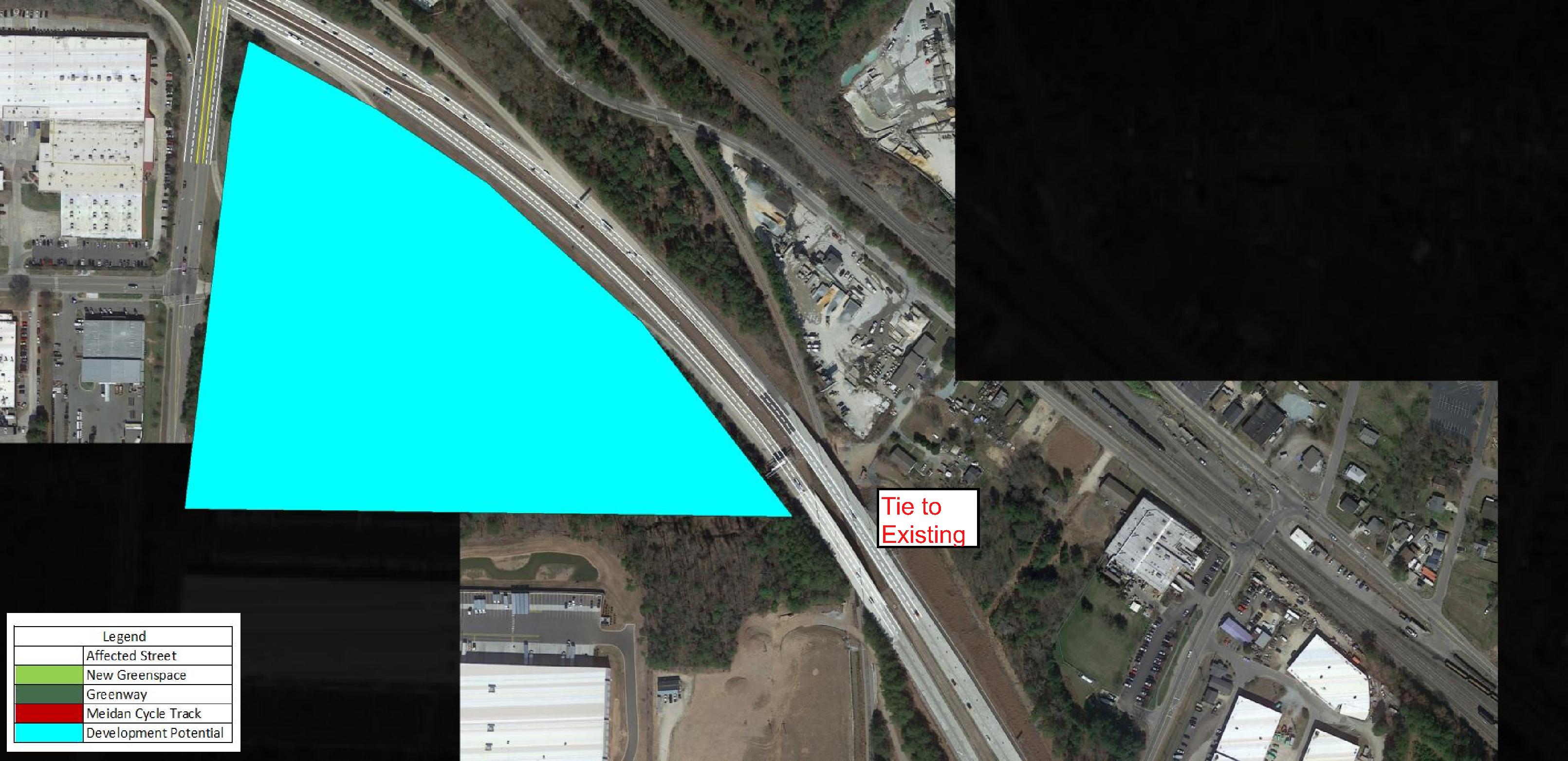
Some high level tidbits on how I did things. - First signal on the West End is at Anderson near Duke Hospital - Last signal on the East End is at Briggs Ave - A linear Park with Greenway along side "Durham Blvd" from the West end to the Lakeland Street pedestrian bridge - A two-way median cycle track from the West end to the Lakeland Street pedestrian bridge. This would ensure dedicated signals and as few conflicts as possible at every intersection - A total of 18 new signalized intersections of "Durham Blvd" - this ensures any through traffic will use East End Connector, and that Durham Blvd is a slow speed urban gateway - Approx 20 new development parcels from the elimination of the on / off ramps - "Durham Crossing Park" just south of DBAP Just the thought of this is very exciting and I really think with how perceptions are changing in the US in terms of infrastructure funding, this could really have some legs. Challenges - Cost (of course) - Converting bridges to at-grade I still need to tidy this up and PDF / label the sheets but here is a preview!         |
Re: 147: From Freeway to Boulevard - Pt 1: Design
|
Administrator
|
Wow! I love this so much!
My favorite part is how you created the "urban blvd" with the commercial and residential uses as the street that runs by ATC2/Durham Bulls Stadium and the new street created south of that has more of the greenway, cycle track uses. I also love the Durham Crossing Park. With ATC 2 going in nearby, this park would solidify this area as an amazing place to hang out. Imagine a big park with trails, playground, spaces for food vendors (food trucks and carts) and even stages for programming. It would be so fantastic. Great work. I am wondering if: 1. You'd be up for creating a little PDF report that would show these sections and have a little more detailed description (I realize this is more work, so no pressure). 2. If there is a PDF, if you'd be ok with me writing a blog post about it and linking to that PDF. |
Re: 147: From Freeway to Boulevard - Pt 1: Design
|
Administrator
|
Great - also, what is your site?
If it makes more sense to just link to your site, I can do that as well. Certainly want to give you due credit for this work! |
|
Thanks! here's the link http://https://philveasley.com/2022/02/04/sketching-the-durham-freeway-conversion-idea/
|
|
In reply to this post by pveasley
Sort of off topic, but given what you mentioned about highways, what are your thoughts on I-240 in Asheville? I feel like that is also approaching the end of its life and has somewhat of a similar effect to 147 in Durham. Pretty sure NCDOT is planning to reroute I-26 from its current alignment over the French Broad River, supposed to be a $1B project so it seems like it would be as good of a time as ever to lay the groundwork for a more appropriate road through Asheville.
|
|
I’m not too familiar with the dynamics of that one but I do know the project has been thrown around for decades now.
I think that’s a bit harder since it’s a main interstate (26) You wouldn’t be able to have a gap in the interstate and have it still be an interstate. FHWA wouldn’t allow the gap to happen and honestly it’d be more harm than good to have all the freight traffic have to be on roads. As for 240, once 26 is rerouted / fixed whatever they’re doing I could see making the case for the NE quadrant of 240 being removed. If not, there does look to be some capping opportunities just north of Downtown since a lot of the roads cross over the interstate. |
|
From what I understand, this is what will happen in Asheville. I-26 currently comes up from the south, merges with I-240 to cross the river, then splits off and heads north up to Johnson City. The plan is to extend the freeway behind the EarthFare plaza, build a new bridge over the French Broad River, and merge back with the rest of I-26. I believe the current bridge and series of interchanges on either side is signed as 'Future I-26' as they are not up to interstate standards, however the rest of I-26 is fine.
Current situation: 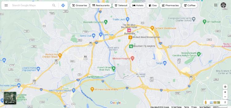 Planned construction: 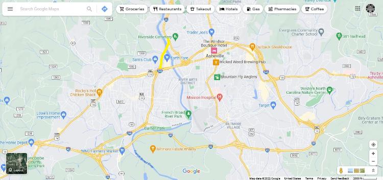 Ideally, I think the old leg of I-26 on the east side of the river should just be removed along with what we currently know as I-240. The section on the left side of the river would just become I-26, and the rest would be removed altogether. The newly-created space (especially through downtown) could be used for new parks and streets to stitch the urban fabric back together. Best-case scenario: 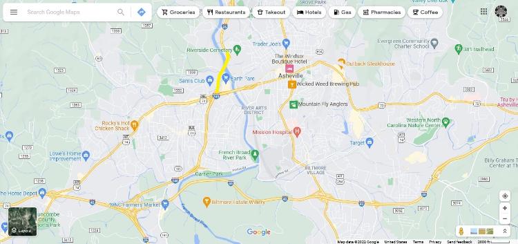 Even though these are different cities, I feel like Asheville and Durham are somewhat similar with how their downtown freeways rip through the urban fabric of the city. Asheville is probably worse in this regard, but I think if there is anywhere to attempt a freeway removal in NC, Asheville or Durham are the only cities that would potentially have enough local resources and political motivation to do so. |
«
Return to Building Bull City Posts
|
1 view|%1 views
| Free forum by Nabble | Edit this page |


